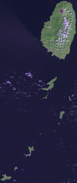
Saint Vincent and the Grenadines is one of the many island countries to be found in the Caribbean Sea. Located in the Lesser Antilles, Saint Vincent is part of the southern end of the Windward Islands and forms part of the border between the Caribbean and the Atlantic Ocean. One of the smallest countries in the world (it’s listed at 203 out of 249 total sovereign nations and their territories), Saint Vincent still manages to post of population of 120,000 inhabitants, resulting in density of 300 people per square kilometer.
The island was originally a stronghold for the Carib natives, and remained so until 1719. This is when French settlers too control and started plantations of coffee, cotton, indigo, sugar, and tobacco. The British took control in 1763, and the island changed hands several times until the British took permanent possession in 1783.
The island was considered a colonial possession of the crown from 1783 till 1979, when Saint Vincent gained its independence. Curiously, a referendum to make the country a republic and replace Queen Elizabeth with a president as the head of state was defeated in 2009, with 55 precent of the population voting against the decision.